Added 1 new A* page:A lot of what NASA does isn't just looking out at space, but looking back at Earth *from* space. For instance, how 'bout them forests?
A map released in 2010 showed forest heights around the world, with a particular focus on the continental United States. Using readings from reflected laser pulses ("LIDAR") collected by three satellites--NASA's ICESat, Terra, and Aqua--the agency was able to determine the heights of trees in forest, and compile that into a detailed map. The highest forests were found in the Pacific Northwest (yay! :) and parts of southeast Asia. Here's the map of forest heights in the United States:
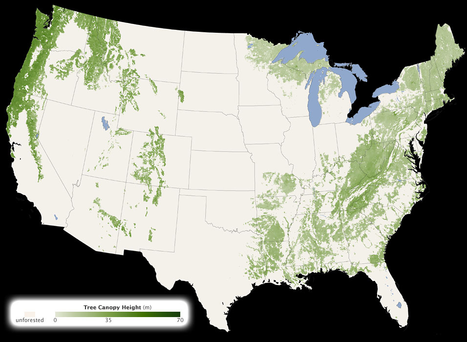
image by NASA Earth Observatory/Image by Jesse Allen and Robert Simmon/Based on data from Michael Lefsky (source)
They went one better in 2011, putting together even more detailed maps, collaborating "with the U.S. Forest Service and the U.S. Geological Survey (USGS) to assemble a national forest map from space-based radar and optical sensors, computer modeling, and a massive amount of ground-based data." An estimated 5 million trees were measured! The "space-based radar" data came "from the Shuttle Radar Topography Mission, which was flown on the space shuttle Endeavour in 2000." Wikipedia says Endeavour was outfitted with two radar antennae for the mission: "One antenna was located in the Shuttle's payload bay, the other a critical change from the SIR-C/X-SAR, allowing single-pass interferometry on the end of a 60-meter (200-foot) mast that extended from the payload bay once the Shuttle was in space. The technique employed is known as Interferometric Synthetic Aperture Radar," which uses "differences in the phase of the [reflected radar] waves" to determine heights in great detail.
They combined that data with Landsat satellite images and on-the-ground measurements by the U.S. Forest Service to come up with a very detailed map of biomass across the country--not just how high the trees are, but how dense they are, so they were also able to map the overall carbon content of the forests. Here's the US biomass map:
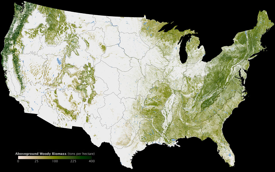
image by NASA Earth Observatory; map by Robert Simmon, based on multiple data sets compiled and analyzed by the Woods Hole Research Center. Data inputs include the Shuttle Radar Topography Mission, the National Land Cover Database (based on Landsat) and the Forest Inventory and Analysis of the U.S. Forest Service. Caption by Michael Carlowicz. (source)
Here's a zoomed-in view of the Pacific Northwest:
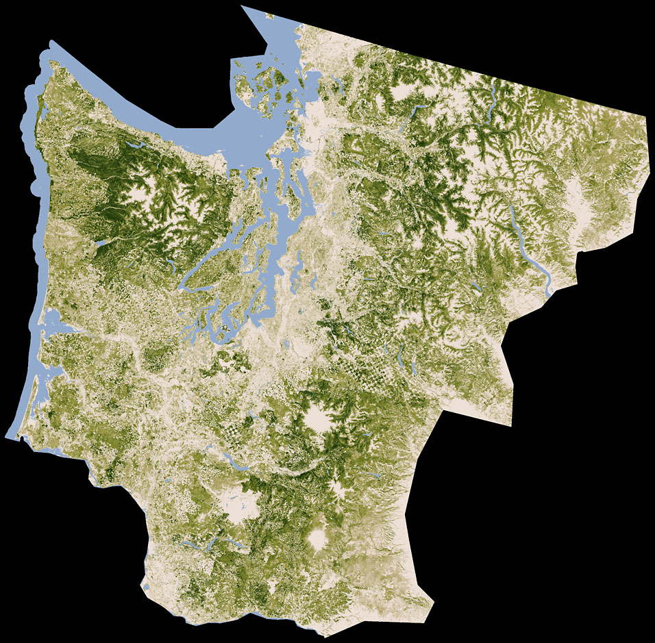
image by Robert Simmon, based on data from Woods Hole Research Center (source)
Those grid patterns in the center (just below Seattle, which is on the mid-east side of that big inlet, which is Puget Sound) are from logging!
| The coastal Pacific Northwest of the United States has the tallest trees in North America, averaging as much as 40 meters (131 feet) in height. It has the densest biomassthe total mass of organisms living within a given areain the country. |
| A rule of thumb for ecologists is that the amount of carbon stored in a tree equals 50 percent of its dry biomass. So if you can estimate the biomass of all the trees in the forest, you can estimate how much carbon is being stored. If you keep tracking it over time, you can know something about how much carbon is being absorbed from the atmosphere or lost to it. |
| In a recent report by the U.S. Forest Service, researchers noted that while the federal government owns slightly less than 50 percent of the forest land in the Pacific Northwest, it controls more then 67 percent of the old-growth in the region. That percentage is rising not because of new federal acquisitions, but because harvesting removed about 13 percent (491,000 acres) of old- and late-sucessional forest on non-federal lands. (The main reason for old-growth loss on federal lands is forest fire.) |
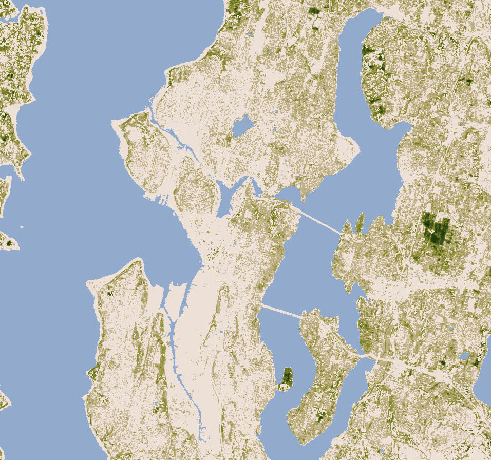
Here's the Seattle area at the released map's highest detail level; my biomass is just to the left of that biggish lake in the north central area!
|